


It pains me to say it, but there is no world in which hundreds of thousands of young people travelling to study at universities in September makes sense during a pandemic.
If we were truly “following the science” (or at least, following the data) we would have delayed the start of term, or everyone would be studying from home. But, as Jim Dickinson – and Independent Sage – notes, here we are. Independent Sage suggests that all courses should be offered remotely, but it stops short of saying students should be living remotely.
Mass migration of young people in the UK is not simply a university problem. We can, and will, “covid-proof” campuses all day. It is a local and regional public health issue, and universities should be contributors to an approach led by public health commissioners and local government.
Not just universities
When we talk about higher education, it’s very tempting to move directly to talking about individual universities.
Even those with limited contact with the sector will have a notion of the character and “prestige” of providers, and we’re used to using this as a way into understanding what all providers should and should not be doing. Right at the start of the pandemic, for example, we watched and counted as each university made its own autonomous decision to move to online provision in its own time.
We’ve started to see this again as each provider makes a decision to offer primarily online provision with some limited face-to-face elements. We’ve seen each provider decide independently on how to keep students and staff safe this autumn – and although guidance and case studies have been made available, it has been an autonomous decision.
From a public health perspective, this cannot continue into the autumn.
Geography lesson
Each university sits within a local area. In many towns and cities, there are multiple providers of higher education situated in similar areas (as Mark Leach suggests, they should be talking to each other already). Because of the topography of a town, students from different providers tend to live in similar areas. They use the same shops, the same streets, the same buses and trains, the same pubs, clubs, and cafes. Here, there is no meaningful distinction to be made between students at different providers. There are student-y areas, and less student-y areas. But even then, there are outliers – many non-students live or work in student areas, many students live away from the main student areas and commute into campus from elsewhere.
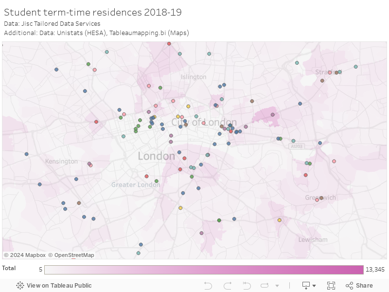
We’ve never been able to look at this effect before, because we’ve never been able to bring you data in sufficient detail. The detail in these illustrations comes via the Jisc Tailored Data services from the HESA student record. We are looking at the numbers of HE students (all levels) with a term time address registered in each post code sector.
Your postcode sector is derived from your postcode – the numbers and letters before the gap, and the numbers after the gap. So, for example, the Office for Students’ postcode sector for the Nicholson House office is BS34 8.
Bristol
As an example, this is an image showing where students live in or around Bristol (there’s an interactive map at the end of the article).

The darker shapes show postcode areas with higher numbers of students, the circles are the campuses of HE providers. Frenchay (BS16 1) up to the North West has two UWE campuses, and a large number of halls of residence. Just under five thousand students lived there last year. There were also 675 students in Filton, and many more further down the Gloucester Road in places like Bishopton (1,535), and Horfield (1,260). Then we get down to the likes of Redland (750) and Stokes Croft (1,560) which likely feature students from UWE and the University of Bristol. Not all of these are the classic “student area” of popular imagination, student households often live alongside young families and other non-students.
There’s a pile more students living in the city centre (primarily in private halls rather than houses, and from both main providers), and then Bristol students extend through Cotham (3,245) and Clifton Down (2,400) up to where their main halls are in Sneyd Park and Stoke Bishop (2,360), not forgetting the hall on the other side of the Avon Gorge (525 in Abbots Leigh) and the big nice houses in Clifton Village (1,365). And I’ve not even mentioned students at BPP or the University of Law, the Conservatoire, or local FE colleges. Or the other UWE campuses to the south of the city.
But student numbers are higher in all areas of Bristol than in a non-university city (Swindon is a good comparator). And nearly every postcode sector in the country has some non-distance learning, non-placement students living there, and commuting to campus.
Super-spreaders?
In early autumn, we see the largest mass-migration event in the UK calendar. Young people (primarily but not exclusively 18 year olds) move from nearly every part of the UK to a place of residence in a small number of university towns and cities. There is data on where they come from, though it is indicative:
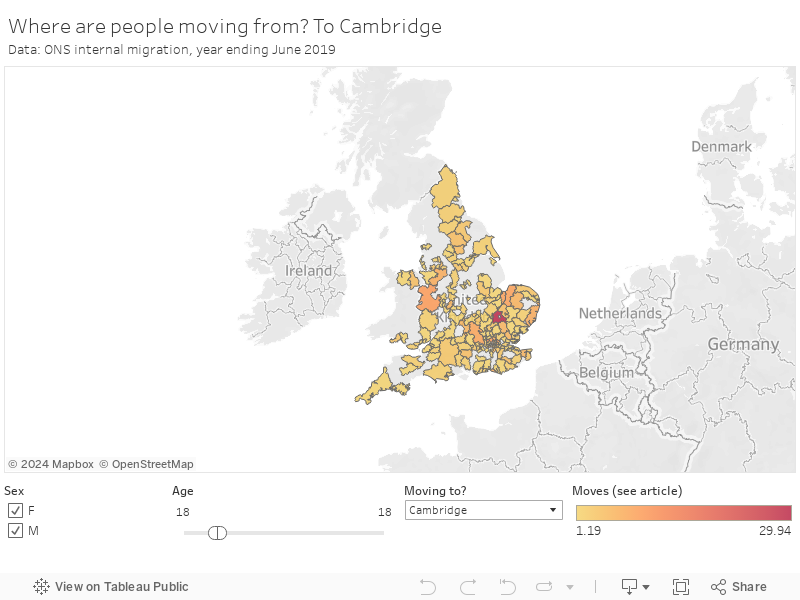
What we can’t see easily are the movements of people who are not freshers. Some students in other years will move regularly between their original domicile and their term time address, others will be returning to their term time address for the first time in September. There is a case for compulsory testing of students, but to have any impact this should really be happening before students travel.
What will they do when they arrive? They’ll move into those provider owned and private halls, to HMOs they share with other students (not always from the same course or even the same university), and to rented rooms with local families. The idea that they will spend 3 hours a week on campus getting their contact time, and the rest of the week in their rooms online, is patently nonsense.
A dry cough, a temperature, a headache, blurred vision – this pretty much describes every morning for some freshers. If you are stressed, eating mainly junk food, drinking a bit much, and getting to know (putting it as delicately as possible) a number of delightful new friends you are likely to pick up any infection going around. And when you mix people from all round the country, pretty much every infection is going round. Freshers’ flu is the catch-all term for many of these, but some pretty nasty stuff (meningitis, for instance) has cropped up in the past.
How many freshers with these symptoms will report these to their university or the NHS as potential Covid-19? How many will if the impact is a whole flat or house full of people you have just met get locked in their rooms for more than a week? And then – as possible cases mount – a whole hall, a whole student village, a whole street, a whole neighbourhood?
On the buses
Universities and students unions are working to provide some other activities. But this doesn’t fix everything. For instance – how do students get from where they live to the campus? In many cases it will be public transport.
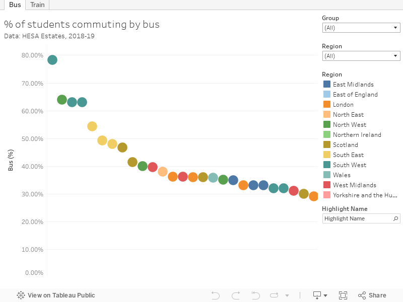
Students in Bath, in Lancaster, in Bournemouth, in Sussex use a lot of buses. An awful lot of buses (but if you will build campuses on top of a hill…). In London, students will be cramming on to the tube or local rail. This isn’t just an issue for one university, or for all of the local HE providers, or the bus company. Local transport planning, and local public health planning, need to be in the lead.
This applies for literally anything else students may do other than study. Most universities have thought about cafes, bars, restaurants, and nightclubs. What about house parties? Are we considering churches and mosques? Gyms, hairdressers, and nail bars? Late night takeaways? Shops?
All of these are also used by local residents as well. The scaling up of capacity will be familiar from this time every year. The scaling up of public health measures is not.
Birmingham
We’ve all read that Birmingham is bubbling under as regards a local lockdown. Here’s where the students live:

The big cluster towards the bottom is around the University of Birmingham. There’s a bunch of halls of residence in three massive university-owned “villages” near by – Selly Oak, Pritchatt’s Park, and Vale Villages – and numerous private halls. Lots of students live in HMOs around Selly Oak – but as the university has its own well-served railway station a fair number live in the city (Birmingham didn’t return HESA estates data in 2019-20 but in the previous year about 16 per cent commuted by train) along with students from Aston, Birmingham City University, University College Birmingham and a host of other alternative providers. There’s also BCUs “City South” campus by Edgebaston.
Imagine a Birmingham local lockdown in September. Depending where the line is drawn (as we saw in Leicester it doesn’t always follow city or county boundaries) we could have students living in an area with a lockdown, but studying in an area without. Or vice versa. Or both living and studying in areas with no lockdown, but needing to pass through a “sealed off” area in the middle to get between the two.
Imagine who the residents of Selly Oak and Bourneville will blame if all of B29 gets locked down.
Imagine how many students will want to travel to an area under lockdown to study, or leave one and go and live at home.
Universities do not have full control over what students do. In general students are a much more sensible lot than they are given credit for, but even doing the same things you do with your mates in a quiet northern market town in the summer (park, bag of cans, daftness) is a level of magnitude more dangerous at the start of term in a university city. Couple that with a long-awaited taste of freedom after a more stressful than usual A level year and we have a serious local (not university) risk that needs to be managed.
This needs collaboration at a local and regional level – universities working together, yes, but also public health commissioners, the NHS, local police, and local government. For me, it is local government that should be taking the lead. But we are short of time, data, and expertise.
Interactive data
You can look at student numbers in any area of the United Kingdom on this map.
Use the search and zoom functions at the top left of the map, or drag the map around, to find areas of interest. The contrasting coloured circles are the locations of every site at which higher education may be going on, based on Unistats data – I’ve also included the number of courses on offer (if there’s no courses now, that could be because all provider courses are “based” at the main campus, or because there were courses but there are no longer). The area shading shows the number of students (see caveats below) that were reported to be living in each postcode sector during the 2018-19 academic year.
This is a hefty chunk of data (hence us using the screen grabs above) – it is unlikely to run smoothly on your phone. I’d recommend searching on your desktop, with a browser with no other tabs open, and closing any resource-heavy software. It moves slowly, but it does move. If you want more detail, do have a word with the Jisc Tailored Data Service team or your own provider’s planning team.
Data information
Data on student term time residence has been provided by the Jisc Tailored Datasets service, drawing on HESA records for the 2018/19 academic year.
Numbers are presented to the nearest 5 students, and values rounded to 0 are not shown. Data shows student term time addresses for the 2018-19 academic year for students at all levels of study, excluding students on industrial placements and distance learning students. Term time addresses were not available for 54,535 students (around 2.5 per cent of the total). The data quality is not brilliant, as anyone who has used this data at a provider level will know. So you should see figures as indicative rather than precise.
We should note that postcodes are not static – new codes are created and older ones “terminated” as buildings are demolished and planned.
Because of a provider level decision to opt out of data provided via Jisc to organisations like Wonkhe, students from Falmouth University, the University of Worcester, and London South Bank University are not shown on this visualisation, along with students from 55 alternative providers.
Postcode boundary data is from TableauMapping.bi.